Walk to Fly
New trail connecting southwest Austin to airport breaks ground in 2025

The trail won't just connect to the airport, but other networks for getting around Austin.
The City of Austin's quarterly trails catch-up newsletter contained a few pieces of exciting news, depending on a reader's neighborhood. First and foremost was an announcement that construction on the Bergstrom Spur Trail — a high-priority project since as long as 10 years ago — is beginning in January.
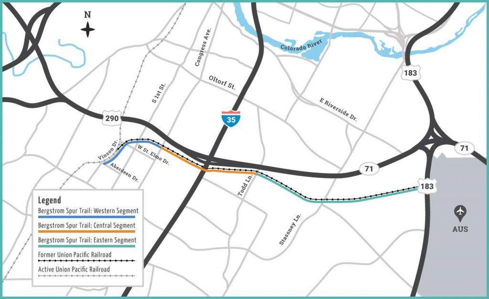
The full trail will be about 6.5 miles long, connecting the airport and southwest Austin following the path of the former Union Pacific Railroad. More specifically, that means it'll connect Vinson Drive, East Riverside Drive, and US-183.
The portion undergoing construction in January will be the first of the project; it'll be about 0.3 miles long and 12 feet wide, stretching "from Aberdeen Drive to the trail head tie-in at the former Union Pacific Railway tracks," according to the newsletter. See the blue segment on the map below.

This portion won't be the whole segment, which will eventually run from Vinson Drive to South Congress Avenue — about 1.12 miles. A web page for the full project breaks down the different segments, what they're meant to connect, and where funding is coming from.
Although the plan is divided into segments, they'll eventually make up one long trail. More construction is scheduled to start in later parts of 2025 on the other segments, which explains the division.
According to the Urban Trails Program via the newsletter, the goal is to "greatly enhance local urban trail access in southwest Austin, improve connectivity, and provide a viable route to walk or bike to the airport."
A priority in the design is connecting other networks for people walking, biking, and taking other forms of public transit.
Other updates in the newsletter reported progress on two East Austin projects: a bridge for pedestrians and bikers over the Longhorn Dam, and some completed phases in the MoKan Trail.

 A picture at Luv Fats Ice Cream in Northeast Austin, where Chi Ndika made small batch vegan ice cream. The shop is in between spaces, but relocating soon.Photo by Steven Hatchett